
Unseasonal rain has swept across Uttar Pradesh from October 27 to 31, 2025, bringing a sudden chill to a state that typically basks in autumn warmth. The unusual weather, triggered by the convergence of a trough from the Arabian Sea and the remnants of Cyclone Montha, has shattered October temperature records and disrupted daily life from Lucknow to Varanasi. The India Meteorological Department (IMD) confirmed that Cyclone Montha, which made landfall along the Andhra Pradesh coast on October 28 with winds of 90–100 km/h, has left behind a trail of clouds, rain, and record-low highs. In Lucknow, the mercury hit just 25.4°C — the lowest maximum temperature in three years for October, eclipsing last year’s 31.2°C. Here’s the thing: this isn’t just a weather blip. It’s a sign of shifting patterns that could redefine how farmers, commuters, and city planners prepare for autumn.
How Two Weather Systems Collided
The story begins with a trough stretching from the east-central Arabian Sea to western Madhya Pradesh, drawing in moisture like a vacuum. Simultaneously, a middle-troposphere trough — a classic western disturbance — moved southeastward. These two systems didn’t just overlap; they amplified each other. By October 27, light showers had already drenched Bundelkhand and western districts like Agra and Firozabad. Then came Cyclone Montha. Formed from a deep depression over the southeast Bay of Bengal, it intensified rapidly, hitting land with gusts up to 110 km/h. Its remnants, though weakened, didn’t vanish — they drifted north, feeding into the existing moisture stream over Uttar Pradesh. The result? A five-day stretch of intermittent rain and thunderstorms, concentrated in the east but touching nearly every district.Temperature Drops That Broke Records
The most startling impact? The collapse of daytime highs. On October 28, Etawah recorded a scorching low of 20°C — nearly 10 degrees below seasonal norms. Hardoi followed at 21°C. Even in the state capital, Lucknow, where October days usually hover around 30°C, the thermometer barely climbed past 25°C. That’s not just cool — it’s anomalous. Senior scientist Atul Kumar Singh of the Lucknow meteorological centre called it “unprecedented for this time of year.” Overnight lows, however, didn’t plummet. In fact, many places saw a slight rise — Meerut at 15.1°C, Bareilly at 15.3°C — suggesting the cloud cover acted like a blanket, trapping heat at night while blocking the sun by day. The contrast is eerie: chilly mornings, damp afternoons, and no relief in sight.
Who’s Affected and How
Farmers in Agra, Jhansi, and Jalaun — districts under heavy rainfall alerts — are scrambling. Rabi crop sowing, which usually begins in late October, has been delayed. “We were ready to plant wheat,” said a farmer from Mainpuri. “Now the fields are waterlogged. If this continues, we’ll lose a whole cycle.” Commuters in Varanasi and Prayagraj faced chaos as thunderstorms knocked out power and flooded low-lying roads. The IMD issued a yellow alert for lightning in eight eastern districts, including Sonbhadra and Chandauli. Schools in Mirzapur suspended outdoor activities. Hospitals reported spikes in respiratory cases among children and the elderly — a direct consequence of damp, cool air lingering indoors.What’s Next? The Slow Fade of Cyclone Montha
By October 31, the Cyclone Montha system is expected to fully dissipate over northern India. But the weather won’t snap back immediately. The IMD warns of lingering showers in Purvanchal through early November, with temperatures remaining 2–4°C below normal. Meanwhile, western India — Maharashtra, Gujarat, and Goa — also saw heavy rain from October 28–30, suggesting a broader atmospheric shift. Experts are watching for signs of El Niño’s return, which could mean more erratic monsoon behavior in the coming years.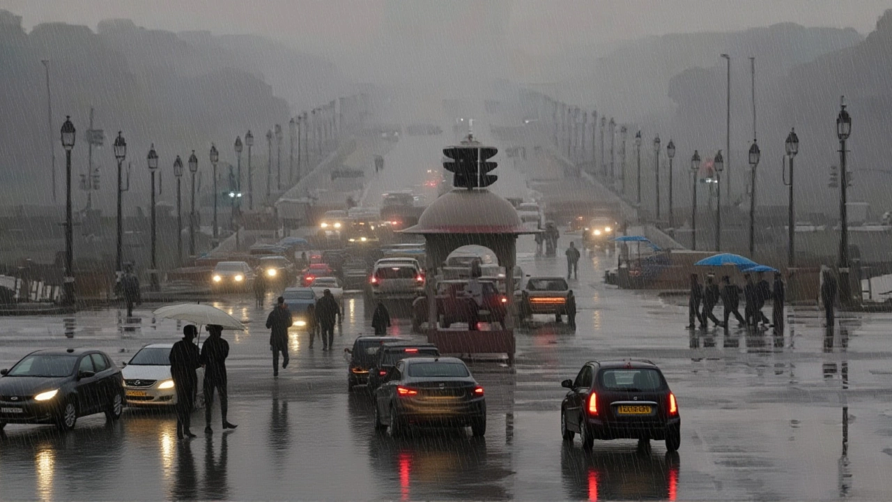
Why This Matters Beyond the Rain
This isn’t just about umbrellas and colds. Unseasonal rain in October — traditionally a dry, sunny month — is a red flag for climate scientists. Uttar Pradesh has seen three such anomalies in the last five years. The frequency is rising. Agriculture, water management, and urban infrastructure weren’t designed for this. Power grids buckle under sudden storms. Crop calendars are thrown off. Even tourism — a major revenue source in Agra and Varanasi — takes a hit when visitors cancel trips due to unpredictable weather. The IMD says it’s monitoring closely. But adaptation? That’s up to policymakers.Frequently Asked Questions
How did Cyclone Montha affect Uttar Pradesh despite making landfall in Andhra Pradesh?
Though Cyclone Montha hit the Andhra coast, its remnants traveled northwest as a weakened low-pressure system, drawing moisture from the Bay of Bengal into Uttar Pradesh’s atmosphere. This combined with an existing trough over the Arabian Sea, creating prolonged cloud cover and rainfall across the state — even in areas hundreds of kilometers from the original landfall.
Why did minimum temperatures rise while maximums dropped?
Persistent cloud cover blocked daytime sunlight, keeping highs unusually low — around 20–25°C instead of the typical 30–35°C. At night, those same clouds trapped heat radiating from the ground, preventing temperatures from falling as much as usual. That’s why nights stayed warmer than normal while days felt like early winter.
Which districts received the heaviest rainfall, and why?
Agra, Jhansi, Jalaun, Etawah, and Firozabad in western UP saw the heaviest rain due to their position directly in the path of moisture-laden winds from the Arabian Sea trough. Meanwhile, eastern districts like Varanasi and Prayagraj were hit by the remnants of Cyclone Montha, which funneled moisture from the Bay of Bengal. The convergence of both systems made these zones the epicenters of rainfall.
Is this level of unseasonal rain becoming more common in Uttar Pradesh?
Yes. Since 2020, Uttar Pradesh has recorded five unseasonal rainfall events in October and November — double the frequency of the previous decade. Climate models suggest rising sea surface temperatures in the Arabian Sea and Bay of Bengal are fueling more intense, erratic systems. Experts warn this trend will likely continue, demanding urgent updates to agricultural and urban planning policies.
What does this mean for farmers preparing for the rabi season?
Delaying wheat and mustard sowing by even 10–15 days can reduce yields by up to 20%, according to ICAR data. Waterlogged fields also increase the risk of fungal diseases in seedlings. Farmers in Agra and Jalaun are now advised to wait for soil drainage and use drought-resistant varieties if planting resumes. The state agriculture department has issued advisories, but many smallholders lack access to timely information.
Are other parts of India experiencing similar weather?
Yes. Maharashtra, Gujarat, Konkan, and Goa also saw heavy rainfall between October 28–30 due to the same atmospheric setup. IMD noted winds of 30–50 km/h across coastal areas, with lightning alerts in multiple districts. This suggests a broader monsoon withdrawal anomaly — not just a local event — potentially linked to larger climate oscillations like the Indian Ocean Dipole.
Releted Post


Aarav Sengupta
Hello, I am Aarav Sengupta, a consulting and marketing expert with a passion for Indian culture and current affairs. I love to delve into the intricacies of Indian life and share my insights through writing. With a keen eye on the Indian news landscape, I strive to bring valuable perspectives on various topics. My goal is to provide readers with a fresh, engaging, and informative outlook on Indian society and the world of marketing.
Comments
Post Comment